As rainy as this spring has been, you may want to learn how to check out the flood conditions in your area.
Almost everyone knows that floodplains are the lowlands and relatively flat areas adjoining waterways that are subject to flooding. Floodplains are, in fact, an extension of the water system. Their natural function is to help move high water volumes downstream or to store the water until flooding subsides. They provide a variety of functions including flood water storage, filtration and removal of water pollutants, channel stability and erosion control, wildlife habitat, beauty and recreational opportunities and stream baseflow. Building and developing on flood plains disrupts the ability of floodplains to perform these vital functions. Not to mention the danger that flooding causes to property, homes, and lives.
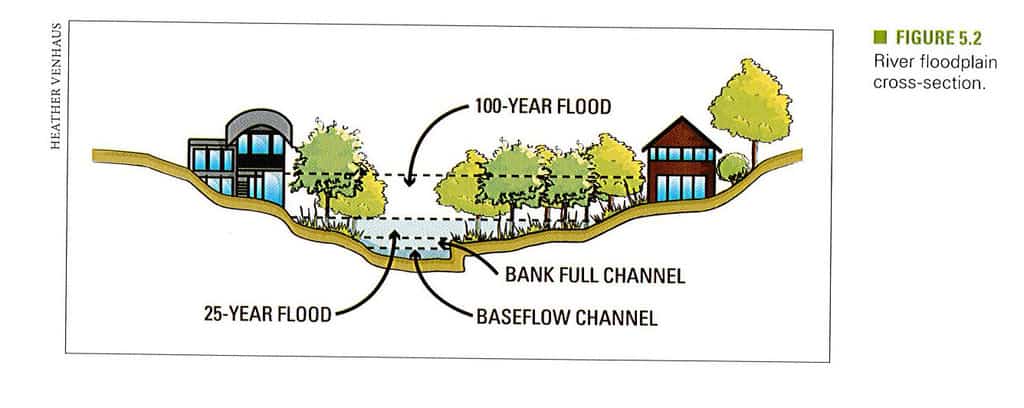
We’ve heard of the 100-year-floodplain, but perhaps don’t know that it doesn’t mean that a flood will only occur every hundred years. Floodplains are classified by the likelihood of flooding in a given year. An elevation that has a 1% chance of being flooded each year is designated as a 100-year-floodplain. In fact, 100-year-floods (and floods of any designation) can occur in a relatively short period of time. Since floods are not consistent in their timing, it can be easy to downplay or ignore the risks until it is too late to prevent damage. In Designing the sustainable site: integrated design strategies for small-scale sites and residential landscapes, Heather Venhaus discusses not only flooding, she includes information on sustainability options for air, water pollution, biodiversity, and more.
Floods are the most frequent of natural disasters and destructive floods occur world-wide: the Indus River basin in Pakistan in 2010; Queensland, Australia; South Africa; Sri Lanka; and the Philippines in late 2010 and early 2011. Other major floods also occurred in 2011: the earthquake-induced tsunami on the north-east coast of Japan; the Mississippi River; Pakistan; and Thailand, including Bangkok.
We here in southeast Iowa know about floods first-hand. To help residents understand localized flooding, the University of Iowa Flood Center (IFC) has developed a new interactive, online tool to access local flood information. The IFC is part of Hydroscience & Engineering (IIHR), a research institute at the UI College of Engineering. It is the nation’s first academic center devoted solely to the study of floods.
The Iowa Flood Information System (IFIS) includes access to current stream and river level data from 19 stream-stage sensors in Johnson County. IFIS provides information that can help Johnson County residents make more informed decisions for flood planning and mitigation. It will also alert community members in advance so they are better able to stay safe and minimize potential flood damage.
The user-friendly, online application displays up-to-the-minute community specific information on rainfall, stream levels, and more, including:
- Iowa River flood inundation maps for Iowa City/Cedar Rapids
- Real-time and historical data on water levels, gauge heights, and rainfall conditions
- 2D and 3D interactive visualizations
- Discharge levels at the Coralville Lake Reservoir
It is “a one-stop web-platform to access community-based flood conditions, forecasts, visualizations, inundation maps, flood-related data, information and applications.” The website has an informative video tutorial which will walk you through the many features available.
Be aware of the flood conditions near you – and stay safe!
RESOURCES:
Venhaus, Heather. 2012. Designing the sustainable site : integrated design strategies for small-scale sites and residential landscapes. Hoboken, N.J : John Wiley & Sons.
Jha, Abhas Kumar. 2012. Cities and flooding : a guide to integrated urban flood risk management for the 21st century. Washington, D.C. : World Bank.
Iowa Flood Center. 2015. University of Iowa.
Iowa Flood Information System. Iowa Flood Center. University of Iowa. Date accessed: June, 2015.
OTHER RESOURCES:
Price, Roland K. 2011. Urban hydroinformatics : data models, and decision support for integrated urban water management. London : IWA Publishing.
Brody, Samuel David. 2011. Rising waters : the causes and consequences of flooding in the United States. Cambridge, New York : Cambridge University Press.
Mambretti, S., editor. 2012. Flood risk assessment and management. Southampton ; Boston : WIT Press.